
This article is the fifth and final article in an incredibly detailed discussion on the important considerations you may have to make if you are bugging out and on the run.
Additional Thoughts
In this final segment we will examine three topics that merit special consideration. If you have (or plan to have) a group that you would hit the trail with, these subjects will be worthy of serious discussion.
The Fallacy of Setting Arbitrary Schedules
If you are traveling on foot, I can virtually guarantee you will not reach any camp site that you preselected for that day. Such goals are difficult enough to achieve if you are bugging out with vehicles, but motorized transportation at least gives you the advantage of bursts of speed if you have to detour. You may be able to make up lost time by driving faster or a bit longer.
Realistically, such options are not likely to exist when your group is on foot. What might have been a plausible schedule for reaching successive camp sites based on a motorized time line becomes unattainable when on foot. Going ‘faster’ means the entire group either has to pick up the pace for extended periods or continue traveling beyond sundown.
There will be innumerable reasons why you cannot maintain a pace needed to reach a predetermined camp site. For example, rainstorms may delay your progress, or scouting activity may force you to lay up for extended periods.
Apart from placing a group that is ill-equipped to travel on foot in the dark, pressing ahead to an arbitrarily selected camp site will add the risk of physical injury. Importantly, you will have lost the ability to mask your tracks while traveling in darkness. They will be there for anyone to see at the next dawn. And, they will lead right to your camp.
This is why, for a group with diverse (and possibly limited) experience and stamina, I maintain a strong bias toward traveling only in daylight; allowing sufficient time to locate and set a concealed and secure camp.
What does this mean? You should constantly be assessing possible campsites along the way. The best location may be at a site that you passed a half-hour earlier.
No one can predict the conditions they will encounter when SHTF. You may have a reasonable understanding of the geography, an idealized route and a passing knowledge of the terrain you will be crossing; but all of it will have been based on perceptions that you gained when things like water fountains actually worked and people weren’t holding rifles when you got near their property.
The goal for each day is to have a group that is still intact and uninjured. It will not matter that you covered only 12 miles rather than twenty.
Trail Discipline
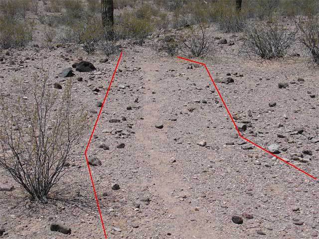
The tracks left by this group greatly exceed what is required for a single file formation.
This topic can be difficult for some people to wrap their brain around, but it is vital, nevertheless. The time to learn and discuss these disciplines is before a member puts the entire group at risk of detection.
- Limit movement on and off the trail. If your point man has you moving in single file formation, it is for a reason. Don’t walk abreast or clump up.
- Keep verbal communication to a minimum and keep it low. If you are having a noisy conversation you are (1) broadcasting your location and (2) are unable to hear an approaching threat.
- Use 2-way radios with headsets to communicate between people who are detached from the group (such as the scout or tail-end Charlie) when necessary.
- Use unambiguous hand signals as often as possible. There is an amazing amount of information that can be conveyed using this technique, but it has to be learned and practiced. (See http://www.lefande.com/hands.html as an example, or search “Military Hand Signals” on the Internet.
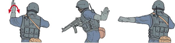
Signals for File Formation, Stop and Line Abreast
- Keep your eye on the guy on point. If he/she signals for everyone to stop, that’s what it means. It doesn’t mean to step away from the trail or that you should rush forward to see what’s going on. Stop! The person behind you may not have a line of sight to the point man. You should repeat the signal for the benefit of those behind you.
Trail discipline applies to everyone. Lack of cooperation will raise everyone’s stress level and could endanger the group.
Planning for Success – Essential Tools
Any individual or group contemplating a cross-country bug-out should incorporate extensive and detailed route planning as part of their Prepper regimen. You may have driven the route a hundred times under normal conditions, but your knowledge will likely be limited to your visual recognition of highways that you may no longer be able to use, or towns that are no longer safe to pass through. There are several tools that can help you plan and execute a route that will minimize your profile and avoid areas that are susceptible to tracks.
GPS

GPS in combination with satellite imagery is the best solution.
One of the tools that I keep handy is a GPS unit. When not otherwise in use, it sits inside a Faraday Box and can be retrieved within a matter of minutes. Loaded in my GPS are pertinent topo maps and key GPS waypoints that would lead me (or anyone in my group) to a variety of locations. As an optimist, I believe that the network of GPS satellites (there are 32 in orbit at present) would survive just about any SHTF situation that can reasonably be imagined. The use of GPS can be of great value if you are navigating across unfamiliar terrain.
Mapping Software
Mapping tools, such as DeLorme, can be similarly used for capturing topographic details (including 3-D) of an extensive route. These images can be downloaded from a computer and stored on a smart phone.
Satellite imagery
Satellite imagery, such as Google Earth, can provide details of terrain and trails that do not appear on maps, and allows you to capture in 3-D mode. These images can also be transferred to a smart phone.
Hard copy topo maps

Communication options are a huge force multiplier.
USGS topographical maps covering the route from your origin to destination can serve as a hard copy backup if you lose power in your GPS unit or smart phone. Frankly, a topo map isn’t going to tell you anything about soil composition (unless it happens to be a swamp) or if the terrain is rocky.
Of the four options listed above, I prefer using GPS in combination with satellite imagery. The value of having GPS is that you will always know where you are relative to your target location, especially if you have had to detour away from your chosen route. Satellite imagery gives you a realistic ‘photo’ of the terrain at just about any level of apparent eye altitude you desire (that is, height above the deck), and allows you to color code trails, locations where there is water, etc. Over the course of the last five years I have located and marked several thousand trails that do not appear on any topo map.
Conclusion
In the final analysis, the level of tracking expertise of a group on your tail may not matter much. If you are leaving a “bright” trail, one that is loaded with sharp tread impressions, trail trash, reckless high sign and other indicators of your route, it will not take much observational or reasoning skill to locate you. Practically speaking, it is impossible to pass over a significant span of terrain – involving multiple days of travel – without leaving any sign. Your goal should be to practice disciplines that will make your passage along that route as “dark” as possible.