
One of the most stressful situations you are likely to encounter in a SHTF event will be the struggle to get to a place of safety. This could be the not-so-simple matter of getting home, or the even more challenging matter of bugging out to a distant place of refuge. If you think about it, it doesn’t really matter whether your destination is 5 miles away or fifty. If you don’t have a clear understanding of how to reach your objective – that is, the routes and terrain (urban, rural or natural) that you will confront – then you are trusting to hope and luck; neither of which qualify as a strategy for survival.
There are several critical aspects to developing a get-home or bug out route, but the first two are planning and confirming. In other words, you have to identify and analyze routes, and then you have to gain a level of certainty that they will serve you reliably under conditions that will very likely be beyond your control.
If you were confronted with a traffic blockage during your daily commute, your first inclination might be to access a mapping tool on your smart phone to help you find a secondary route. But, if the grid is down your handy mapping tool will be useless. SHTF conditions, such as civil disorder, congested roadways, road closures, blockades, lack of fuel or weather conditions, could force you to abandon your preferred route. Without planning, you may have no idea about suitable alternatives – unless you have already researched and confirmed the alternate routes.
You can define, in advance, a primary route and a series of alternate routes that will give you the best chance to reach your destination if you have the right tools and learn how to use them. I am specifically referring to the use of Google Earth, which uses satellite imagery from Landsat. The value of this imagery is that you can examine surface features in great detail, locate roads and trails that do not appear on regular maps, identify sources of water that are not dependent on electric pumps, to name only a few benefits.
Let’s take a high level look at a hypothetical bug out route between an arbitrary point of origin “A” and a destination “B”.
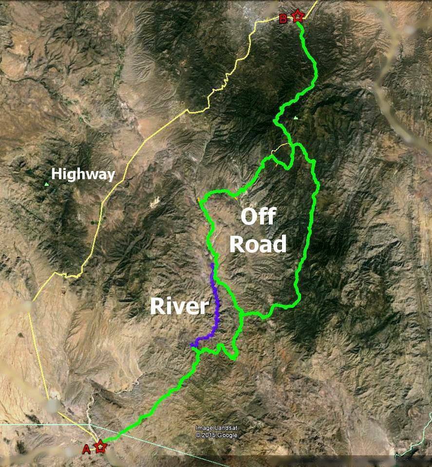
In this example, the tan line on the left is a highway route that spans 65 miles between the origin and destination. This would be the obvious choice for travel, enabling you to reach the destination in about one and a half hours through mountainous country. But what if the highway has been barricaded at a critical choke-point and nothing is getting through?
The green lines show a secondary route that follows 2-track roads to the same destination. Taking the left leg of this route will span a distance of 54 miles, while the right leg will take 55 miles.
The blue line shows a 12 mile stretch of perennial stream flow that could be used if a bug out group was on foot. Several other route options are available, but are omitted for simplicity.
A thorough analysis of the river route with Google Earth will reveal that the gain in elevation is a steady 54 feet per mile over this distance. That is important to know if you are on foot. The green routes will show elevations that range from 2,200 feet to nearly 8,000 feet, with significant (+/-) changes in elevation over very short distances of travel. In other words, this is mountainous terrain and there is a lot of steep ground between A and B.
Let’s take a closer look a small portion of the 2-track trail:
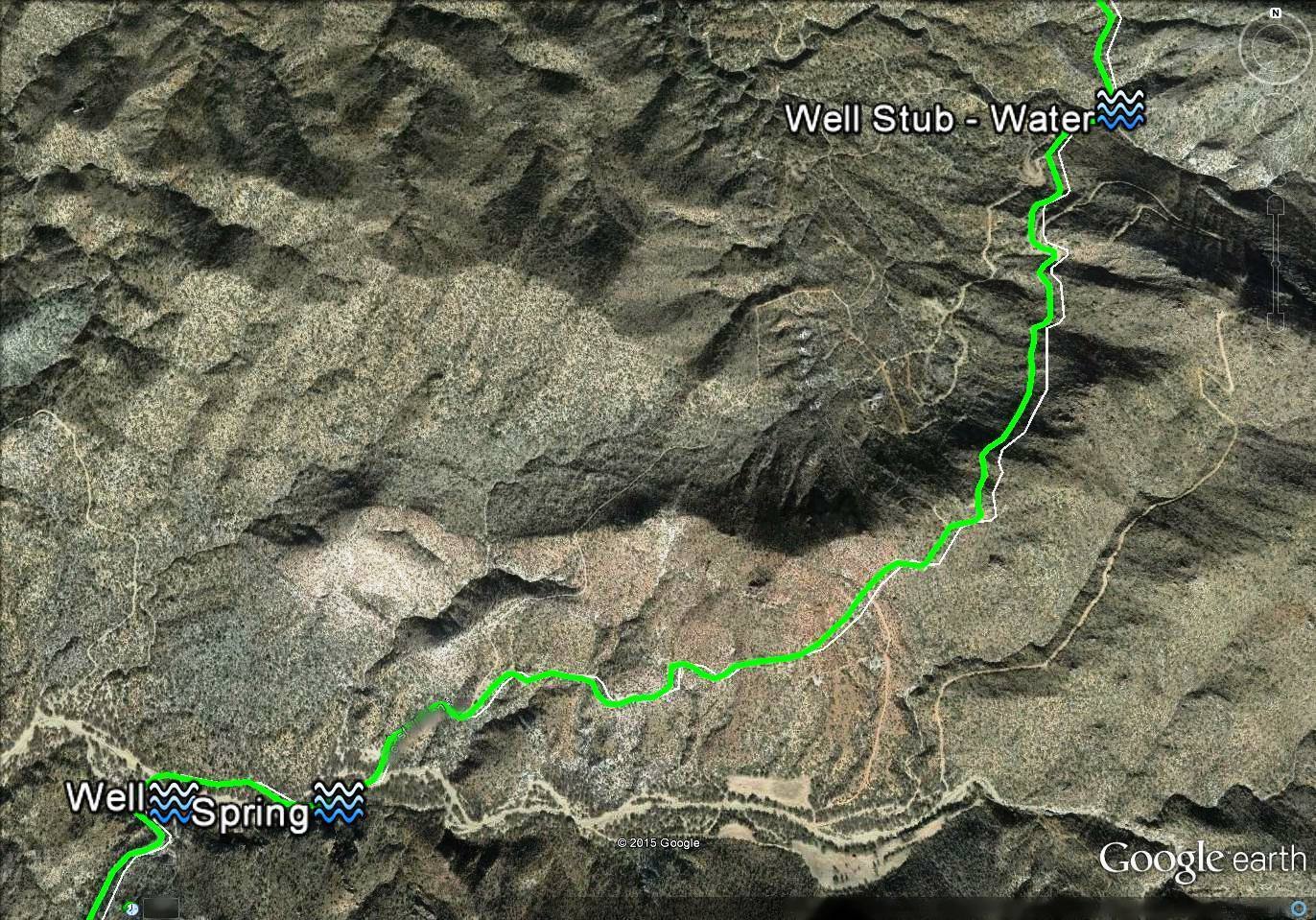
This image identifies just three of many sources of water along the route. It is important to note that only one of these sources appear on USGS Topo maps and two of them are not obvious, even with satellite imagery. So, why are they shown in the photo? They were identified by a detailed inspection of the route. Each source of water is tied to a specific GPS location. In fact, any location on Google Earth can be referenced using standard coordinate formats. The point is that you have to know where these important resources are located beforehand so that you can incorporate them into your route.
Sources of Game
Here is a closer view of the “river route,” which reveals useful information at a moderate viewing altitude
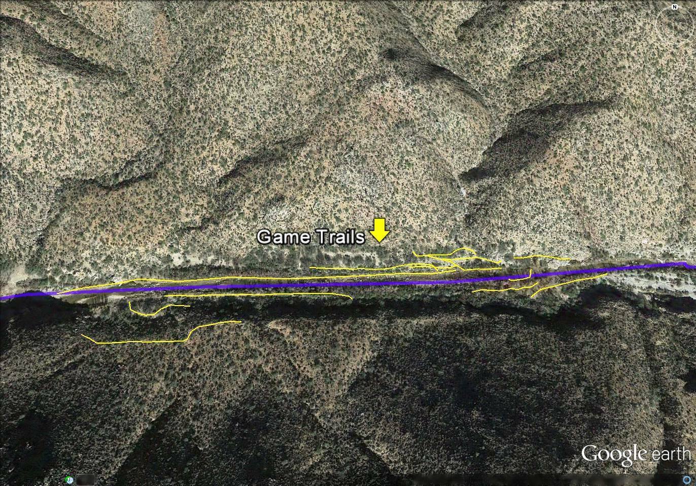
This 2,000 foot segment of surface flow identifies just a few of many game trails, as shown by the yellow lines. Deer and other wildlife can be found here (and at numerous other locations along this stream) throughout the year. Trails are easily identifiable by zooming down to a lower level of “eye altitude.” Analysis of the imagery revealed the game trails, but knowledge of the type and abundance of could only be established by on site verification.
Route Hazards
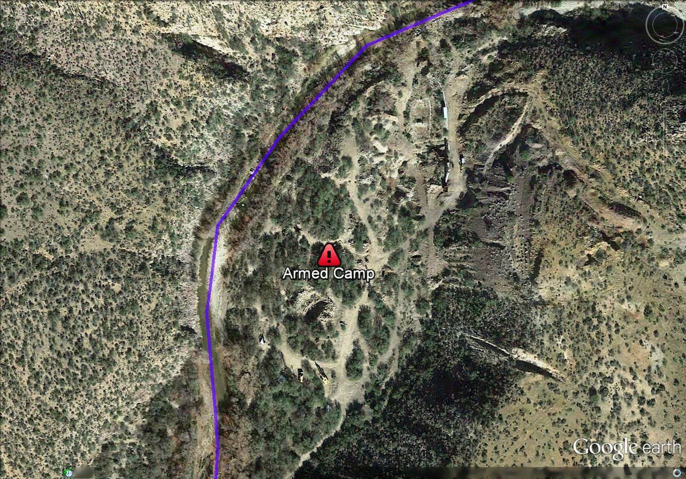
The warning symbol shown in the above image shows a (very real) area that needs to be either bypassed or approached with caution. Once again, you cannot determine that kind of knowledge by simply looking at a map.
An even lower level view of this segment also reveals that you could be hiking in waist-deep water if your route is confined to the stream. I have hiked this area numerous times and know that spring–fall seasons produce a deep canopy of tree cover along this stream. I also know that water flow can be fatally high during heavy monsoon and winter storms. In other words, a photo image is worthless if you cannot apply direct knowledge to the route.
The next image continues with a portion of the green 2-track route, but includes anecdotal information about ways to identify potential navigational hazards that can lead to wasted time and fuel.
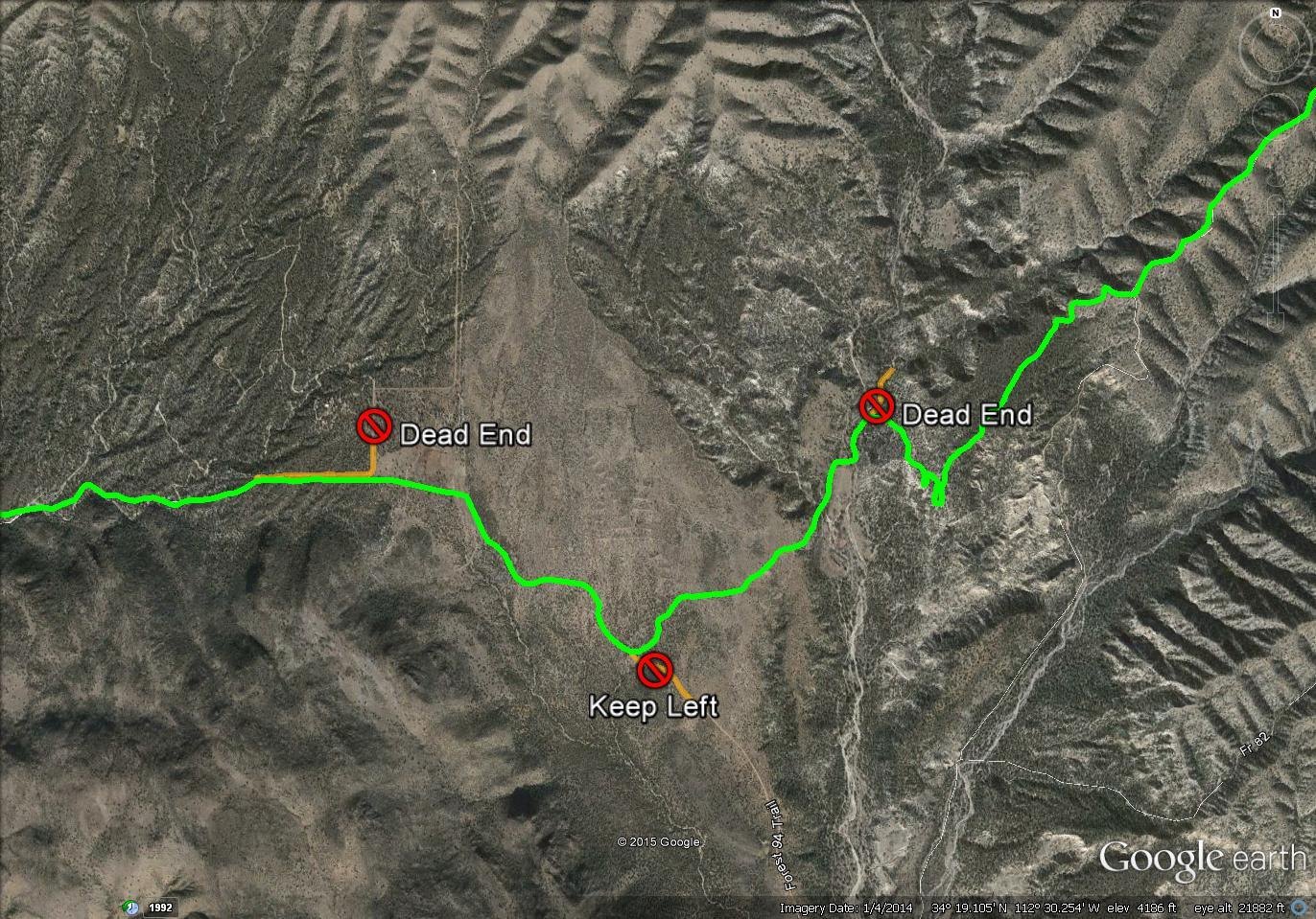
Beginning on the left, I have placed a warning symbol that shows a dead-end 2-track road. The center hazard symbol indicates a trail that needs to be avoided because it leads in a direction that adds distance (and time) to the route. I could have added a dozen or more hazard symbols along this portion of the trail to identify 2-track roads that need to be avoided. Why go to the trouble? You may want to share your Bug Out album with other members of your group, and they may be hours or days behind you. Importantly, they may not know the route as intimately as you do.
There is another vitally important reason for sharing your bug out route: It says “This is where I will be. If I get pushed off this route, I will always strive to get back to it. Look for me there!”
The next image shows a hiking trail that can reduce travel distance by several miles if you are on foot, rather than in a vehicle. As you can see, it is rendered with a 3D perspective that provides a better understanding of the terrain.
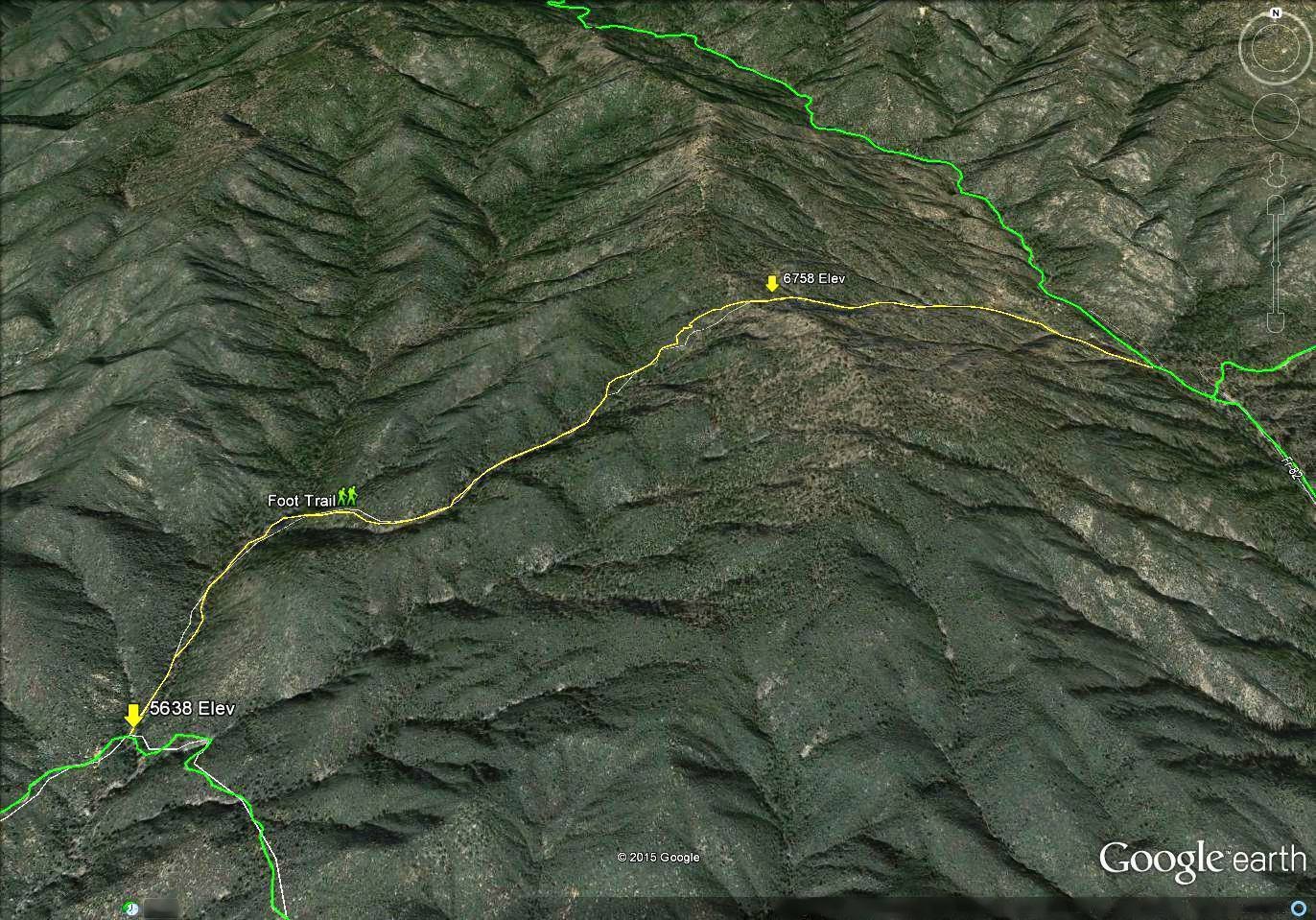
I have annotated the starting elevation of the trail (lower left) and the elevation at the crest of the mountain. There is an overall gain of 1,120 feet to the crest, followed by a drop of 806 feet where the trail joins up with the 2-track road on the right. Route distance is 2.65 miles versus six miles on the 2-track road.
The last image, below, shows the level of detail that you can obtain. In this instance, the “eye altitude” above a frozen water catchment is 370 feet. A portion of the bug out trail is shown along the bottom of the image.
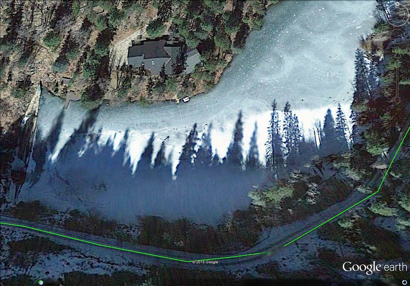
From a practical standpoint it is possible to maintain excellent image quality on Google Earth to as low as 300 feet above the deck. Images begin to degrade below that level, although you can do some very good analysis at lower levels once you gain experience with the tool. Remember however, that at very low viewing levels, the field of view will be limited. For example, at an eye altitude of 300 feet, you will be viewing an area that is approximately 350 feet on the east-west axis by 250 feet on the north-south axis. If you intend to build a photo library using such a low-level, the 55 mile route would require more than 1,100 images! That is entirely unnecessary. All you really have to do is work at an eye altitude that provides the level of detail that you are comfortable with. There will certainly be instances where you want to zoom in on an important location or feature, but that shouldn’t be necessary in most cases.
It is important to understand that satellite images are not depicted in real-time. Google Earth updates individual image panes periodically and could be anywhere from a few weeks to two years old. Is that important? Not really. Highways, county roads, forest trails and buildings don’t move and they certainly don’t disappear between image updates.
As you do the research to build your own Bug Out library, don’t worry about the image date that will be displayed at low levels. Google will update it when they have some economic reason to do so. And when they do, I guarantee that nothing of importance will have changed.
Getting Started
There are only four things that you need in order to develop a bug out library of images:
- A home computer with Internet access
- A downloaded copy of Google Earth (it’s free)
- A method of transferring images
- A smart phone
Beyond these basics, all that you need is the motivation to learn how to navigate Google Earth. There really is no limit to your ability to annotate important information. Any location or feature that is important to your safety and survival can be identified and documented on the image.
Leveraging Value
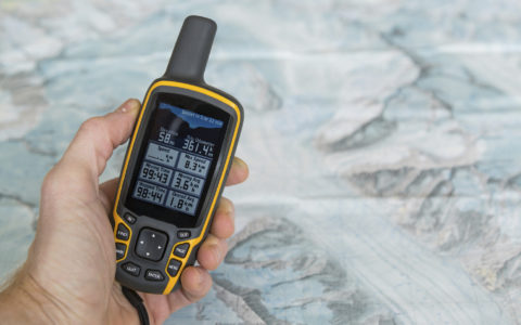
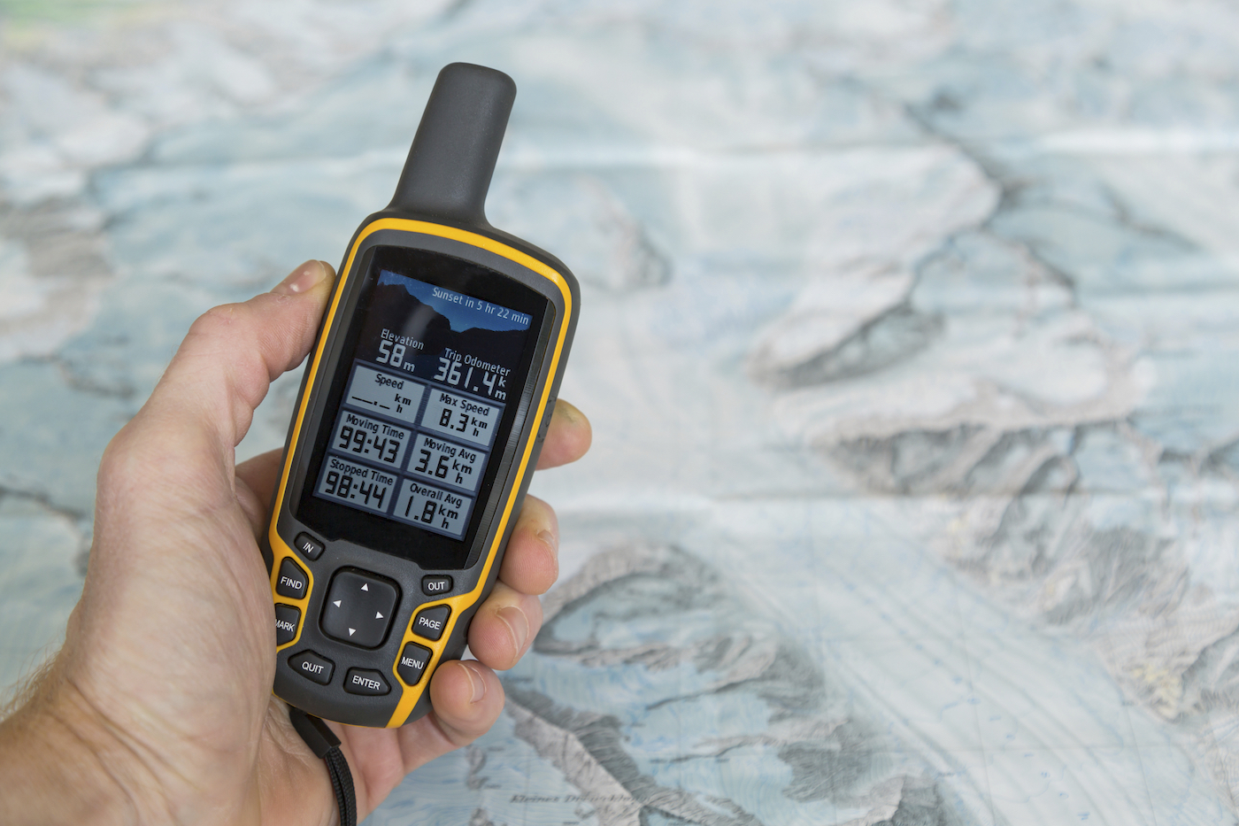
Once you have built your library, I would urge that you incorporate a fifth item to your survival tool bag, and that is a handheld GPS device. The value of this unit is that you can pre-load important coordinates from the bug out routes that you have developed from satellite imagery. The images on your smart phone will be static; that is, you can view them, but you cannot interact with them.
As I’ve said in previous postings, there are many ways that you can get pushed from a desired route. Regardless of the distance, a GPS unit can tell you precisely where you are, where you want to be, as well as the distance and direction of travel required to get back to the preferred route on your smart phone library.
It is well beyond the scope of this article to teach anyone how to use Google Earth. That is something that you must do for yourself. My objective is to illustrate what you can achieve with this remarkable tool once you have learned the basic navigation skills. The bottom line: There is no reason to be lost or uncertain about your position relative to a desired route.